Research Themes
Impact of Mantle Dynamics on Palaeoclimate and Future Sea-Level Change
Early studies of ice age palaeoclimate have tended to assume – with the exception of glacial isostatic adjustment (GIA) and localised tectonic activity – that Earth’s surface has remained a passive, non-deforming substrate. However, new observational constraints show that changes in the pattern of mantle convection can generate relatively rapid vertical surface motions (~100 m per million years). This dynamic component of Earth’s topography has several important ramifications for our understanding of past climate. First, vertical displacement of ancient sea-level markers can lead to inaccurate estimates of ice volume during past warm periods. Secondly, surface elevation changes with respect to sea-level alter the equilibrium position of ice sheet grounding lines (i.e., where ice sheets begins to float), affecting continental ice storage capacity. Thirdly, topographic growth/decay can interact with atmospheric and oceanic circulation patterns, creating lasting changes in regional climate and ice accumulation patterns. Finally, changes in long-wavelength dynamic topography of the surface and core-mantle boundary, as well as internal density anomalies, can modulate the periodicity and amplitude of Earth’s precession, which influences the pacing of glacial-interglacial transitions.
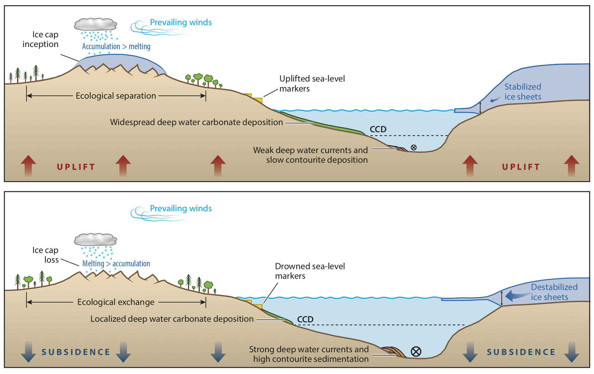
Many sea-level projections are tuned to fit ice loss estimates from the satellite and palaeoclimate record but none of these target values account for the mantle dynamic impacts described above. The resulting forecasts therefore remain subject to deep uncertainty, reducing their utility for decision makers involved in developing adaptation and mitigation strategies. Accurately mapping 3D variations in Earth’s internal structure, and its spatiotemporal evolution is therefore a grand challenge of climate research.
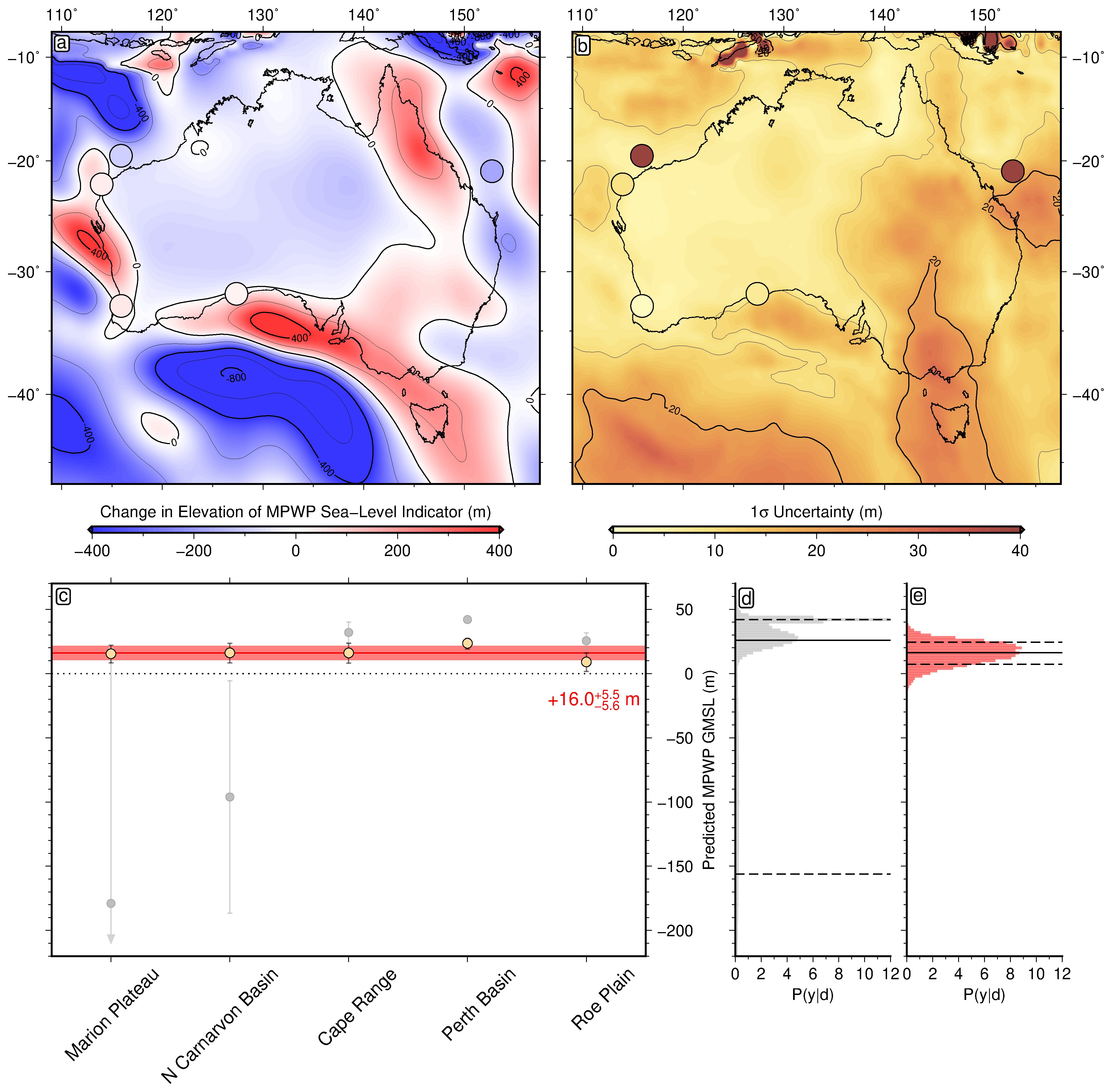
To address this challenge, we are developing new methodologies to accurately convert seismic velocity structure into temperature, density and viscosity, and obtain uncertainties on these quantities. This work has allowed us to generate mantle convection simulations that explain both present-day topographic patterns and changes in elevation inferred from ancient sea-level markers. One important outcome is that during the mid-Pliocene warm period (the last time in Earth history that atmospheric CO2 concentrations were similar to the present), global ice volumes appear to have been larger than previously assumed, ruling out the most pessimistic recent sea-level projections. Another key result is that the eastern coast of Baffin Island has experienced significant convectively-driven uplift in the past 5 million years, potentially explaining geological evidence that Northern Hemisphere glaciation began in the Canadian Arctic rather than Greenland. We have also successfully developed high-resolution models of steady-state viscosity, lithospheric thickness and heat flow beneath Antarctica, using a Bayesian inverse framework to quantify uncertainties in these parameters. In future, we plan to use more sophisticated inverse methods coupled with new geological constraints to extend and refine mantle convection reconstructions, allowing deep Earth-climate interactions to be determined over ~10 million-year timescales.
Collaborators:
David Al-Attar (Cambridge, UK), Jacky Austermann (Columbia, USA), Sophie Coulson (Los Alamos National Laboratory, USA), Blake Dyer (UVic, Canada), Sia Ghelichkhan (ANU, Australia), Saskia Goes (Imperial, UK), James Hazzard (Imperial, UK), Mark Hoggard (ANU, Australia), Andrew Hollyday (Columbia, USA), Harriet Lau (Brown, USA), Andrew Lloyd (Columbia, USA), Bob Myhill (Bristol, UK), Jerry Mitrovica (Harvard, USA), John Naliboff (NM Tech, USA), Tamara Pico (UC Santa Barbara, USA), Gareth Roberts (Imperial, UK), Alessio Rovere (MARUM, Germany).
Publications:
Richards, F. D., Coulson, S. L., Hoggard, M. J., Austermann, J., Dyer, B. & Mitrovica, J. X., 2023. Geodynamically corrected Pliocene shoreline elevations in Australia consistent with midrange projections of Antarctic ice loss, Science Advances, 9, eadg3035, doi: 10.1126/sciadv.adg3035. (PDF)
Richards, F. D., 2023. Quantifying Plio-Pleistocene Global Mean Sea Level Variation, in Elias, S. (ed.) Encyclopedia of Quaternary Science (3rd Edition), Cambridge, MA: Elsevier, doi: 10.1016/B978-0-323-99931-1.00073-8. (PDF)
Hazzard, J. A. N., Richards, F. D., Roberts, G. G. & Goes, S. D. B., 2023. Probabilistic Assessment of Antarctic Thermomechanical Structure: Impacts on Ice Sheet Stability, J. Geophys. Res.: Solid Earth, 128, e2023JB026653, doi: 10.1029/2023JB026653. (PDF)
Rovere, A., Pico, T., Richards, F. D., O’Leary, M. J., Mitrovica, J. X., Goodwin, I. D., Austermann, J. & Latychev, K., 2023. Influence of reef isostasy, dynamic topography, and glacial isostatic adjustment on sea-level records in Northeastern Australia, Commun. Earth Environ., 4, 328, doi: 10.1038/s43247-023-00967-3. (PDF)
Hollyday, A., Austermann, J., Lloyd, A. J., Hoggard, M. J., Richards, F. D. & Rovere, A., 2023. A revised estimate of early Pliocene global mean sea level using geodynamic models of the Patagonian slab window, Geochem. Geophys. Geosyst., 24, e2022GC010648, doi: 10.1029/2022GC010648. (PDF)
Lloyd, A. J., Crawford, O., Al-Attar, D. A., Austermann, J., Hoggard, M. J., Richards, F. D. & Syvret, F., 2023. GIA imaging of 3D mantle viscosity based on paleo sea-level observations - Part I: Sensitivity kernels for an Earth with laterally varying viscosity, accepted at Geophys. J. Int. (PDF)
Austermann, J., Hoggard, M. J., Latychev, K., Richards, F. D. & Mitrovica, J. X., 2021. The effect of lateral variations in Earth structure on Last Interglacial sea level, Geophys. J. Int., 227, 1938-1960, doi: 10.1093/gji/ggab289. (PDF)
Ghelichkhan, S., Fuentes, J. J., Hoggard M. J., Richards, F. D., Mitrovica, J. X., 2021. The Precession Constant and its Long-Term Variation, Icarus, 114172, doi: 10.1016/j.icarus.2020.114172. (PDF)
Mitrovica, J. X., Austermann, J., Coulson, S. L., Creveling, J. R., Hoggard, M. J., Jarvis, G. T. & Richards, F. D., 2020. Dynamic Topography and Ice Age Paleoclimate, Ann. Rev. Earth Planet. Sci., 48, 585-621, doi: 10.1146/annurev-earth-082517-010225. (PDF)
Novel Exploration Methods to Secure Sustainable Supplies of Critical Metals
As the energy transition gathers pace in the coming decades, we are projected to need unprecedented quantities of base metals (copper, zinc, lead and nickel) and associated subsidiary metals (e.g., indium, cobalt, and molybdenum). These elements are critical ingredients in a range of low-carbon technologies, such as electric car batteries and solar photovoltaic cells, but also to the production of food via their use in fungicides and fertilisers. The burgeoning demand for these materials is forecast to outstrip supply in the near future, potentially stalling progress towards a greener future. Pressure is therefore mounting to find new large deposits of critical metal but, despite huge increases in exploration expenditure, no new supergiant deposits of copper (those containing more than 50 million tonnes) have discovered in the last 25 years. This lack of success can be partly attributed to the fact that, in heavily explored regions, most large surficial deposits have already been found. However, exploration beneath sedimentary cover is in its infancy, and it is thought that major ore bodies may lie close to the surface in many intracontinental basins.
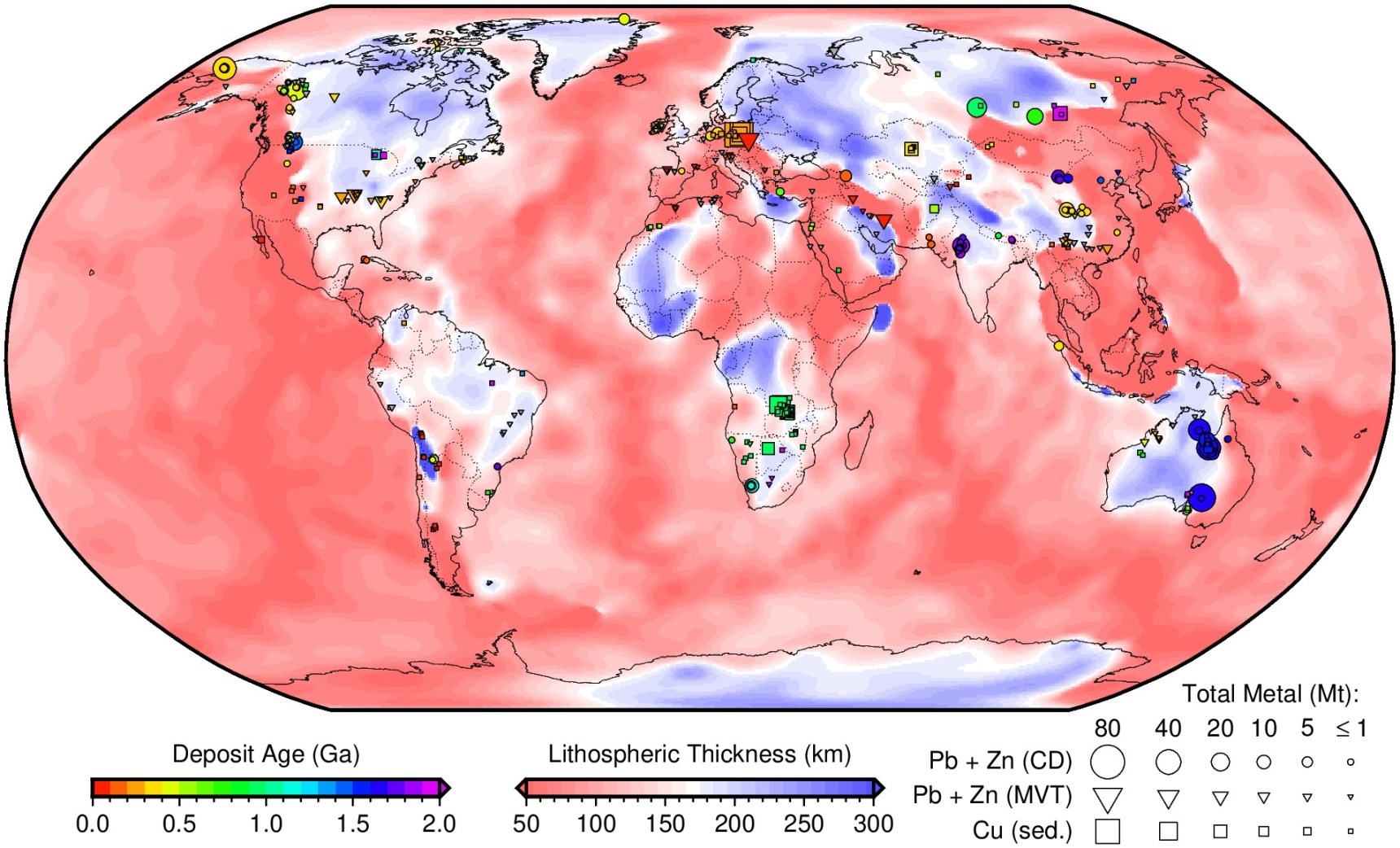
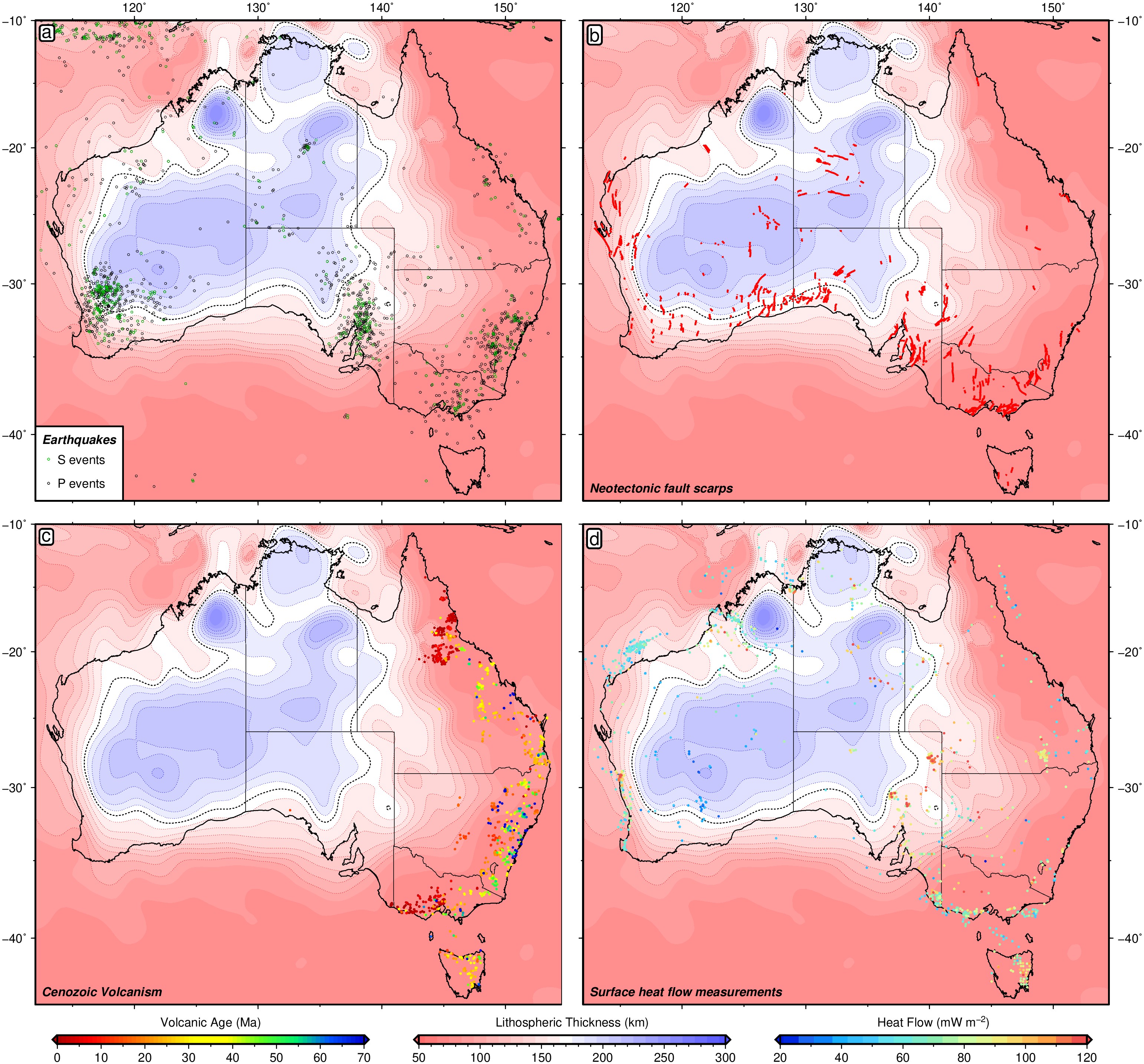
In collaboration with colleagues in Australia, I have mapped out the thickness of the lithosphere at a global scale, revealing a strong and previously unreported relationship between the locations of large sediment-hosted mineral systems and the edges of cratons, the oldest, thickest parts of this layer. In fact, ~85% of all sediment-hosted base metals mined to date, and 100% of all giant deposits (more than 10 million tonnes of metal), occur along this transition.
This discovery is important for several reasons. First, it suggests that there is a link between shallow geological processes operating in sedimentary basins and Earth’s mantle hundreds of kilometers beneath our feet, improving our knowledge of sediment-hosted mineral systems and increasing our ability to predict were others may have developed. Secondly, since these deposits are up to 2 billion years old (which is nearly half the age of the Earth), the relationship suggests that the transition between thick and thin continental lithosphere either persists for billions of years without modification by the plate tectonic cycle, or else, is only destroyed temporarily before regrowing to its original thickness. Finally, our estimates of plate thickness from seismology, in combination with other geological observations, allow identification of new prospective regions for mineral exploration. These ‘treasure maps’ will also work for deposits that are hidden beneath Earth’s surface.
Current projects in this area include: i) integrating other forms of geophysical observation (e.g., magnetotellurics) with numerical modelling work to better understand the link between deep mantle processes and shallow intrabasin mineral systems; ii) using machine learning techniques to narrow down on the key ingredients necessary for a well-developed mineral system; iii) determining the key geodynamic controls on magmatic nickel-copper-PGE deposits.
Collaborators:
Mark Hoggard (ANU, Australia), Karol Czarnota (Geoscience Australia, Australia), David Huston (Geoscience Australia, Australia), Lynton Jaques (ANU, Australia).
Publications:
Huston, D. L., Champion, D. C., Czarnota, K., Duan, J., Hutchens, M., Paradis, S. G., Hoggard, M. J., Ware, B. D., Gibson, G. M., Doublier, M. P., Kelley, K. D., McCafferty, A. E., Hayward, N., Richards, F. D., Tessalina, S. D. & Carr, G. R., 2022. Zinc on the edge: isotopic and geophysical evidence that cratonic edges control shale-hosted zinc-lead deposits, Miner. Deposita, 58, 1–23, doi: 10.1007/s00126-022-01153-9 (PDF)
Hoggard, M. J., Czarnota, K., Richards, F. D., Huston, D. L., Jaques, A. L., & Ghelichkhan, S., 2020. Global distribution of sediment-hosted metals controlled by craton edge stability, Nature Geoscience, 13, 504-510, doi: 10.1038/s41561-020-0593-2. (PDF)
Czarnota, K., Hoggard, M. J., Richards, F. D., Teh, M., Huston, D. L., Jacques, A. L. & Ghelichkhan, S., 2020. Minerals on the edge: Sediment-hosted base metal endowment above steps in lithospheric thickness, Exploring for the Future: Extended Abstracts, Geoscience Australia, Canberra. (PDF)
Huston, D. L., Champion, D. C., Czarnota, K., Hutchens, M., Hoggard, M. J., Ware, B. D., Richards, F. D., Tessalina, S. D., Gibson, G. M. & Carr, G., 2020. Lithospheric-scale controls on zinc-lead-silver deposits of the North Australian Zinc Belt: evidence from isotopic and geophysical data, Exploring for the Future: Extended Abstracts, Geoscience Australia, Canberra. (PDF)
Dynamics and Chemistry of the Deep Earth
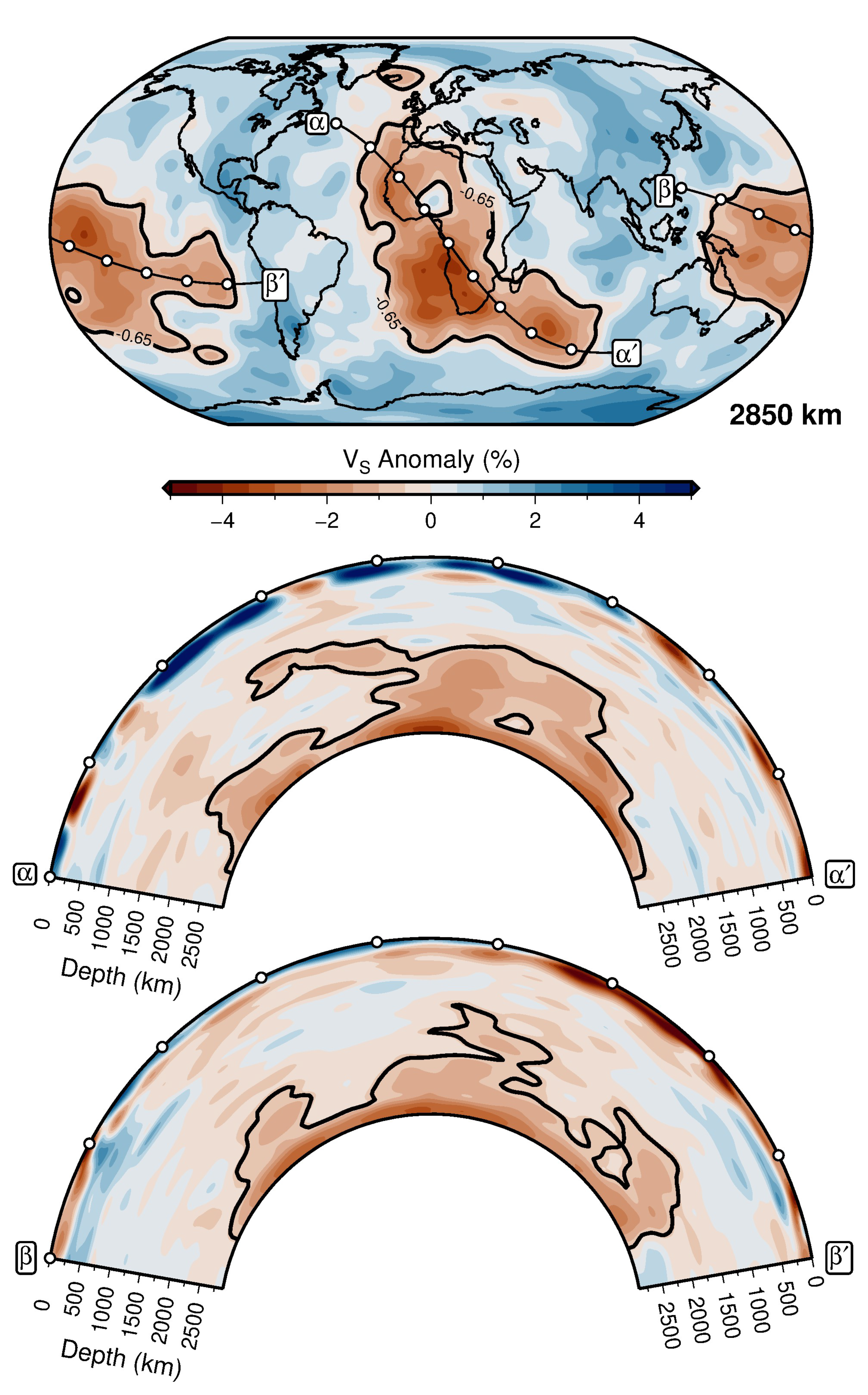
Despite significant advances in our ability to image the deep mantle using seismological techniques, establishing the buoyancy and rheology of identified wave speed anomalies—such as the continent-sized large low velocity provinces (LLVPs)—is complicated by uncertainties in lower mantle composition and the amplitude of seismic attenuation. However, determining the density and viscosity structure of these features is fundamental to improving our understanding of mantle flow patterns and associated deflections of Earth’s core-mantle boundary and surface.
By reconciling multiple novel and independent geodynamic, geodetic, and seismic observations, including revised estimates of Earth’s dynamic topography, semi-diurnal body tide deformation, and Stoneley mode splitting function measurements, we have shown that the deepest ~150 km of the LLVPs comprise compositionally distinct and relatively dense material. Thermodynamic calculations indicate that this dense basal layer likely consists of an iron-enriched basaltic component derived from early-formed oceanic crust. This anomalous chemistry may provide an explanation for both the inferred long-term stability of LLVPs and the primordial isotope signatures of ocean island basalts generated by plumes that rise from these regions. Our proposed model of deep Earth structure therefore satisfies geochemical constraints on Earth’s internal heterogeneity, in addition to the full range of available geophysical observations.
This joint inversion approach shows great promise and will be augmented in future to assess three-dimensional variations in mantle viscosity, the time-dependent evolution of lower mantle structure and its impact on surface processes.
Collaborators:
Mark Hoggard (ANU, Australia), Sia Ghelichkhan (ANU, Australia), Paula Koelemeijer (Royal Holloway, UK), Harriet Lau (UC Berkeley, USA).
Publications:
Richards, F. D., Hoggard, M. J., Ghelichkhan, S., Koelemeijer, P. & Lau, H. C. P., 2023. Geodynamic, geodetic, and seismic constraints favour deflated and dense-cored LLVPs, Earth Plan. Sci. Lett., 602, 117964., doi: 10.1016/j.epsl.2022.117964 (PDF)
Davies, D. R., Ghelichkhan, S., Hoggard, M. J., Valentine, A. P. & Richards, F. D., 2023. Chapter 12: Observations and Models of Dynamic Topography: Current Status and Future Directions, in Duarte, J. C. (ed.) Dynamics of plate tectonics and mantle convection. Cambridge, MA: Elsevier, doi: 10.1016/B978-0-323-85733-8.00017-2. (PDF)
Mapping the Thermomechanical Structure of the Upper Mantle
The thermomechanical structure of Earth’s lithosphere and its interaction with the underlying asthenosphere exerts a fundamental control on Earth’s internal dynamics and its surface expression. Some features of the lithosphere-asthenosphere system are well understood, such as the cooling and sinking of oceanic lithosphere as a function of age, and the importance of a low-viscosity asthenosphere for ‘lubricating’ plate motions. However, many important details of this upper mantle structure remain unclear, including: i) the degree to which the rheological boundary between the lithosphere and asthenosphere is time-dependent; ii) the chemical heterogeneity of the continental lithosphere and its impact on long-term stability; and iii) whether small-scale convection can explain the apparent ‘flattening’ of sea-floor subsidence in older oceanic basins, and rapid vertical motions and magmatism at continental margins.
We have been tackling these questions by merging insights from recent experiments on the frequency-dependence of mantle rheology across seismic to convective timescales, new high-resolution tomographic images of the shallow upper mantle, and petrological data sets that constrain the temperature structure of this region. By comparing xenolith-derived measurements of palaeo-lithospheric thickness with seismic estimates of present-day structure, this work has found that thermal erosion of the base of the lithosphere can generate significant topography and drainage reorganisation (e.g., Angola). We have also demonstrated that advection of asthenospheric temperature anomalies, consistent with petrological estimates, can explain short-wavelength vertical motions of Earth’s surface. Lastly, we have shown that thermomechanically self-consistent simulations of upper mantle flow generate oceanic subsidence and gravity predictions that are fully consistent with those of plate cooling models.
Questions we aim to tackle going forward include disentangling the chemical versus thermal contributions to the lithospheric heterogeneity of continents and determining how lithosphere thins and rethickens during emplacement of Large Igneous Provinces.
Collaborators:
Mark Hoggard (ANU, Australia), Alistair Crosby (BP, UK), Sia Ghelichkhan (ANU, Australia), Megan Holdt (Cambridge, UK), Simon Stephenson (Oxford, UK), Yasuko Takei (Tokyo, Japan), Nicky White (Cambridge, UK).
Publications:
Stephenson, S. N., Ball, P. W. & Richards, F. D., 2023. Destruction and regrowth of lithospheric mantle beneath large igneous provinces, Science Advances, 9, eadf6216, doi: 10.1126/sciadv.adf6216. (PDF)
Richards, F. D., Hoggard, M. J., Crosby, A. G., Ghelichkhan, S. & White, N. J., 2020. Structure and Dynamics of the Oceanic Lithosphere-Asthenosphere System, Phys. Earth Planet. Int., 309, 106559. doi: 10.1029/2019GC008771. (PDF)
Richards, F. D., Hoggard, M. J., White, N. J. & Ghelichkhan, S., 2020. Quantifying the relationship between short-wavelength dynamic topography and thermomechanical structure of the upper mantle using calibrated parameterization of anelasticity, 125, e2019JB019062, doi: 10.1029/2019JB019062. (PDF)
Klöcking, M., Hoggard, M. J., Rodríguez Tribaldos, V., Richards, F. D., Guimarães, J. A., Maclennan, J. C. & White, N. J., 2020. A tale of two domes: Neogene to recent volcanism and dynamic uplift of northeast Brazil and southwest Africa, Earth Planet. Sci. Lett., 547, 116464, doi: 10.1016/j.epsl.2020.116464. (PDF)
Richards, F. D., Hoggard M. J., Cowton, L. R. & White N. J., 2018. Reassessing the Thermal Structure of Oceanic Lithosphere with Revised Global Inventories of Basement Depths and Heat Flow Measurements, J. Geophys. Res.: Solid Earth, 123, 9136-9161, doi: 10.1029/2018JB015998. (PDF)
Richards, F. D., Kalnins L. M. & Watts A. B., Cohen, B. E. & Beaman R. J., 2018. The Morphology of the Tasmantid Seamounts: Interactions Between Tectonic Inheritance and Magmatic Evolution, Geochem. Geophys. Geosyst., 19, 3870-3891, doi: 10.1029/2018GC007821. (PDF)
Continental Vertical Motions: Impacts on Landscape Evolution
The evolution of Earth’s continental topography is governed by the competition between vertical surface motions, which generate relief, and sedimentary processes, that (generally) act to reduce it. The uplift and subsidence history of these regions is therefore encoded in the morphology of their landscapes and may be deciphered if rates of erosion and deposition can be independently verified. Although at small spatiotemporal scales, sedimentary processes and their interaction with the bedrock geology can become complex and non-linear, recent work has shown that simple erosional laws explain behaviour at larger spatiotemporal scales (100s-1000s of km and millions of years). This result suggests that reconstructing the long-wavelength vertical motions of Earth’s continents is hypothetically feasible for at least the past ~65 million years. If these reconstructions can be reliably obtained, they would provide important constraints on Earth’s internal dynamics, the link between key climatic events and topographic changes, and the influence of palaeogeographic shifts on speciation patterns.
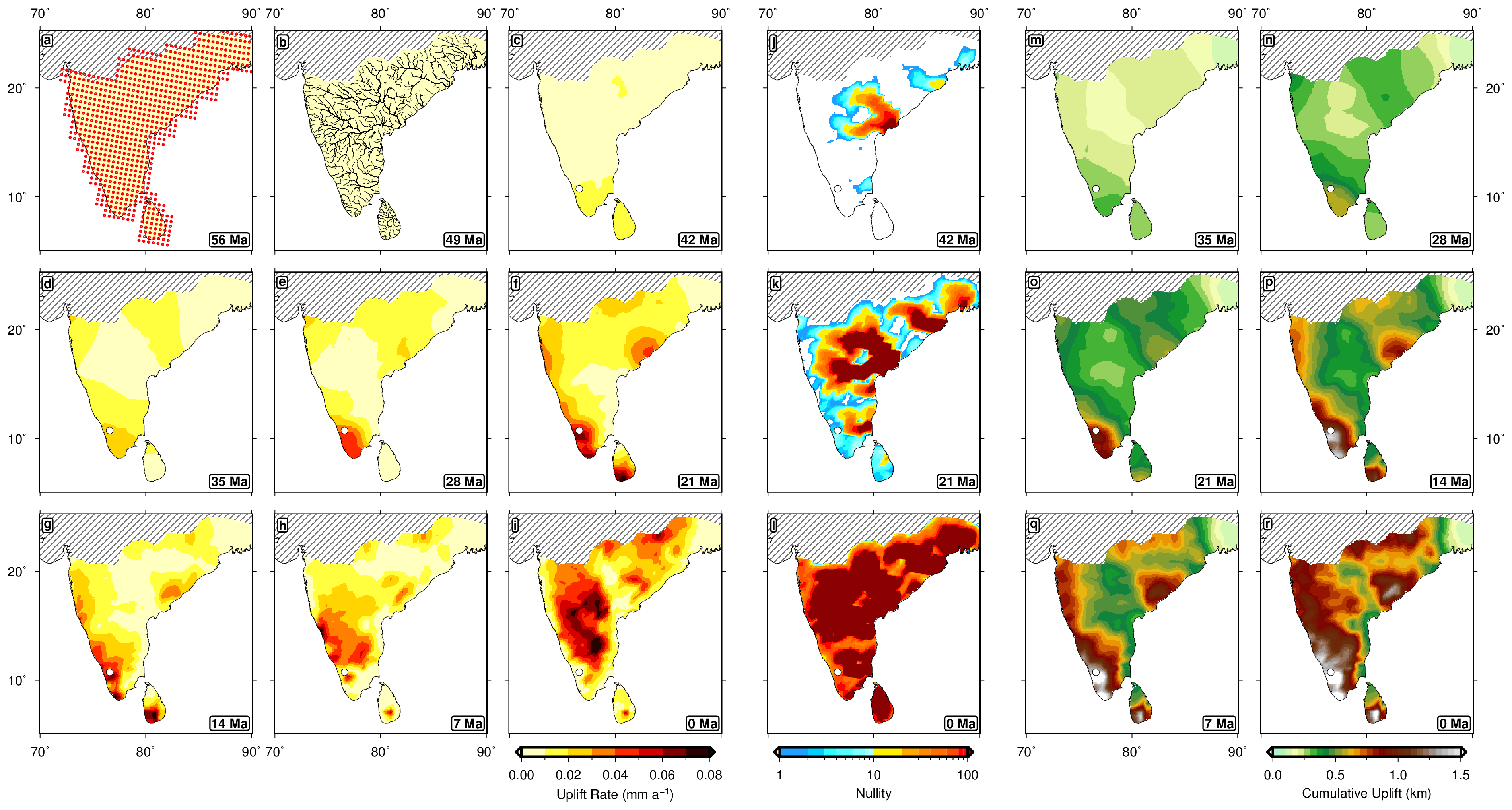
Recent work in this area has investigated the longevity of passive margin escarpments, and the uplift mechanisms responsible for their evolution. Focusing on Peninsular India, we integrated several geophysical and geomorphological datasets with inverse models of drainage evolution to show that most of the Western Ghat’s present-day elevation can be tied to uplift over the past ~25 million years, likely generated by lateral advection of warm anomalies beneath the plate. This result demonstrated that dynamic topography can evolve more rapidly than predicted by many numerical modelling studies (~100 m per million years), with important consequences for our understanding of other passive margin escarpments (e.g., Great Escarpment, Australia). We also found that the recent growth of the Western Ghats as a topographic barrier can explain Miocene intensification of the Southern Indian monsoon and west-east divergence in speciation patterns. This finding provides evidence that major biological and climatological shifts can be linked to the evolving planform of mantle convection.
The inverse modelling framework applied to date is remarkably successful, however, it only accounts for erosion within river channels and is insensitive to subsidence. In the coming years, we aim to combine sophisticated inverse methods with efficient landscape evolution models and new sedimentary datasets to generate more complete histories of continental vertical motion. These outputs will dramatically improve reconstructions of Earth’s time-dependent mantle convection, past sea-levels, and palaeoclimate.
Collaborators:
Gareth Roberts (Imperial, UK), Conor O’Malley (Imperial, UK), Marthe Klöcking (Göttingen, Germany), Verónica Rodríguez-Tribaldos (GFZ Potsdam, Germany), Mark Hoggard (ANU, Australia), Nicky White (Cambridge, UK).
Publications:
Klöcking, M., Hoggard, M. J., Rodríguez Tribaldos, V., Richards, F. D., Guimarães, J. A., Maclennan, J. C. & White, N. J., 2020. A tale of two domes: Neogene to recent volcanism and dynamic uplift of northeast Brazil and southwest Africa, Earth Planet. Sci. Lett., 547, 116464, doi: 10.1016/j.epsl.2020.116464. (PDF)
Richards, F. D., Hoggard M. J. & White, N. J., 2016. Cenozoic Epeirogeny of the Indian Peninsula, Geochem. Geophys. Geosyst., 17, 1525-2027, doi: 10.1002/2016GC006545. (PDF)